Hiking volcano Acatenango
While nomading in Antigua, I couldn’t help myself and find the most crazy adventure you can do there. Hiking volcano Acatenango—was that adventure for me.
Acatenango
Acatenango is a stratovolcano that is joined with Fuego volcano, and together they form a complex known as La Horqueta. Acatenango last erupted in December 1972, and is now considered dormant. Fuego, on the other hand, is active and throws ash and lava every 15–30 minutes.
Hiking Acatenango requires 2 days. Some people do overnight hike, when you start ascending at night, and descent in the morning. But I did the regular overnight hike.
Finding a tour operator
Like many activities in Guatemala, hiking Acatenango on your is dangerous. Even though Acatenango is a national park, the hike goes through corn fields before you reach the entrance to the national park. And it’s known that robberies occur on such roads. So it’s always important to hike with an organized group.
There are many tour operators located in Antigua. I’m not going to cover all of them, but I’ll write a bit about the one I went with.
Wicho & Charlie’s
W&C is tour operator that does Acatenango hike. They are located in Antigua, and they are very cool.
Firstly, they have the best base camp location among all operators. You sleep inside a hut, and not a tent, and the windows of the hut overlook Fuego. This is very handy as you can stay in the comfort of your sleeping bag, while observing the eruptions from Fuego.
Secondly, they provide gear rental. You can rent everything from them, although I would not recommend renting clothes. My wife and I, had all the clothes we needed, but we did rent backpacks and hiking poles. They have a relatively good selection of gear, and I was happy to see Osprey backpacks available.
Thirdly, they provide you with food. Their food is vegan/vegetarian, which might be a bummer for some, but as a meat eater—I enjoyed their meals. And you have to carry your food, which is a nice bonus for me since I came for the adventure, and the suffering.
Note: you can pay a porter to carry your backpack. I find it useless, as carrying my own gear is part of the challenge for me.
Lastly, their guides are very experienced and speak English.
I highly recommend you check them out at Whicho & Charlie’s.
The first day
The day starts at W&C office where you will have breakfast, rent the necessary gear, and have a briefing. At around 9am, you will board a bus from Antigua, and will be taken to a small town called Aldea La Soledad. The town is located at 2200 meters, and there you will start your ascent at around 10:30 am.
The ascent takes between 4 and 6 hours, and is very steep. You will cross some corn fields, and after about 1 hour you will reach the entrance to the national park. From there, the ascent will continue, and you will pass a cloud forest, and an arctic forest, before reaching the base camp at 3600 meters.
Temperature will change drastically. You will start, hopefully, during a sunny day—and will end up in a very cold environment. So it’s very important to have at least 3 layers and a waterproof jacket. During my hike we had rain, so the waterproof jacket was very helpful.
After reaching the base camp, you will have two options: (1) rest and (2) ascent Fuego.
Option 1: Ascending Fuego
The ascent on Fuego starts at 4 pm, so you have to reach the base camp by that time. Keep in mind that if until that point the hike was hard for you, Fuego ascend will be much harder. It’s a 4-hour hike (in addition to the 4 to 6 hours you already did), which goes down a bit, and then turns into a very, very steep ascend on gravel road.
Neither me nor my wife did Fuego ascent. When we arrived at the base camp, it was very cloudy with zero visibility of Fuego. From the people in our group who did Fuego ascent, we understood that they saw nothing.
Option 2: Rest and recharge
If you decide to skip Fuego, you will be given some time to rest and recharge. You will be able to chill near a fireplace, and at 8 pm you will have dinner before going to sleep. By that time, the group that decided to ascent Fuego—should be back already.
Day 2
As with the first day, here too, you have two options.
Option 1 - be ready at 4 am sharp
The base camp is located at 3600 meters, while the summit of Acatenango is at 3976 meters. After getting some sleep (which will be very minimal, trust me), you will have the option to be ready at 4 am for a summit sunrise hike. The summit hike takes about 2 hours, of which you will spend about 20–30 minutes at the top, meeting the sunrise.
Nobody from our group did that. We set our alarms for 3:40 am, but woke up to the sound of intense rain hitting our metal roof. So. Option 2.
Options 2 - meet the sunrise at the base camp
The second option is to wake up whenever. However, if you want to meet the sunrise, you need to be awake at around 5 am. Which we did, and it was amazing! All the rain ended, the clouds cleared, and we had an incredible opportunity to witness an unobstructed Fuego and a few eruptions.
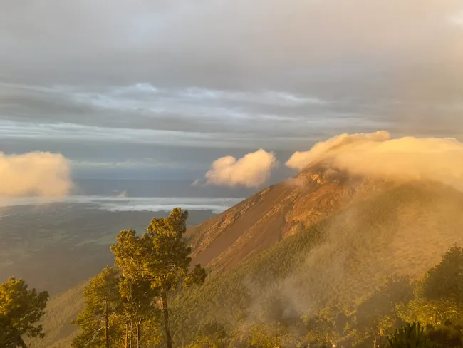
It’s easily one of the most magic views I ever saw. Being there, at 3600 meters, high above the clouds, near an active volcano.
Then at around 7 am you will have breakfast, and start to descend. The way down is much easier, and takes about 2 hours. By around 10-11 am you are back at Aldea La Soledad, and by 12 am—1 pm you are back at W&C office to return the rental gear and go rest.
Frequently mentioned questions
I’m a very organized person. And I care deeply about my life and my health. Therefore, before attempting (most of) crazy adventures in my life—I do a proper research. This time was no different. And so I want to address some common questions you might have, because from what I read online it’s the hardest thing people ever did, and you can die from altitude sickness.
How difficult it is?
As I said, some people online claimed this hike to be the hardest things they ever did. I know that people like to exaggerate, but I rely on reviews and opinions online, so here is mine.
Neither my wife nor I are in athletic shape. My wife does a lot of yoga; I do gym and boxing. Neither of us are runners. We do like walking though.
This hike was challenging. The ascent is constant, and you get about 15-20 minute section of flatness. It’s a total of about 1600 meters of elevation gain. Our calf muscles were hurting for the next 3 days. But it’s far from the hardest thing I ever did in my life.
It’s doable if you are somewhat active, and in shape. I highly recommend you get hiking poles. I usually oppose hiking poles, but during this hike they were very useful both on the way up, and the way down. The soil is very soft, and it’s raining often, so additional points of contact are helpful.
It’s also worth noting that none of us did either of the summits. Maybe if you do the summit, it will be the hardest thing in your life.
Weather
I want to say a few words about the weather. From my understanding, August is the beginning of rainy season. We had rain on the way up, and it was raining all night. It also got very cold on the top. I don’t know what temperature it was, but I suspect it dropped below zero Celsius. Keep in mind that different seasons will have different weather.
Can you get altitude sickness?
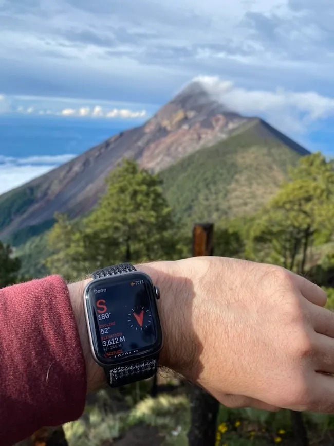
I don’t know. I’m not a doctor. I used my Apple Watch to measure SpO2, and the lowest I got was 88% (everything below 95% is considered dangerous, according to internet experts). Keep in mind that Apple Watch is not as accurate as a dedicated blood oxygen measuring device.
Technically, you can get altitude sickness above 2500 meters. It’s recommend that you stay in Antigua for a few days before attempting the hike, since Antigua is located at 1500 meters. This can give you some time to get used to the altitude.
The other thing that I know, is that when you summit Kilimanjaro—which is 5895 meters—the guides carry blood oxygen measuring devices, and supplemental oxygen. Neither of this was carried by our guides, and so I assume altitude sickness is not that big of an issue on Acatenango.
From our group only one girl had symptoms of dizziness on the way up. But she hiked Pacaya (2550 meters) the day before, which is in my opinion—not a smart thing to do.
If you have any concerns, consult with your doctor and the tour agency. It’s also recommended to take a day of rest before the hike. And stay hydrated. The group is moving in a relatively slow pace, and the guides make sure everyone is doing okay.
Happy hiking.